5 Essential Tips to Understand Easting and Northing Coordinates

In the world of geography, surveying, and navigation, understanding coordinate systems is crucial. One of the most widely used systems is the Cartesian coordinate system, which employs easting and northing values to precisely locate points on the Earth’s surface. Whether you’re a GIS professional, a surveyor, or simply someone interested in maps, grasping these concepts is essential. Here are five indispensable tips to help you master easting and northing coordinates.
1. Grasp the Basics: What Are Easting and Northing?
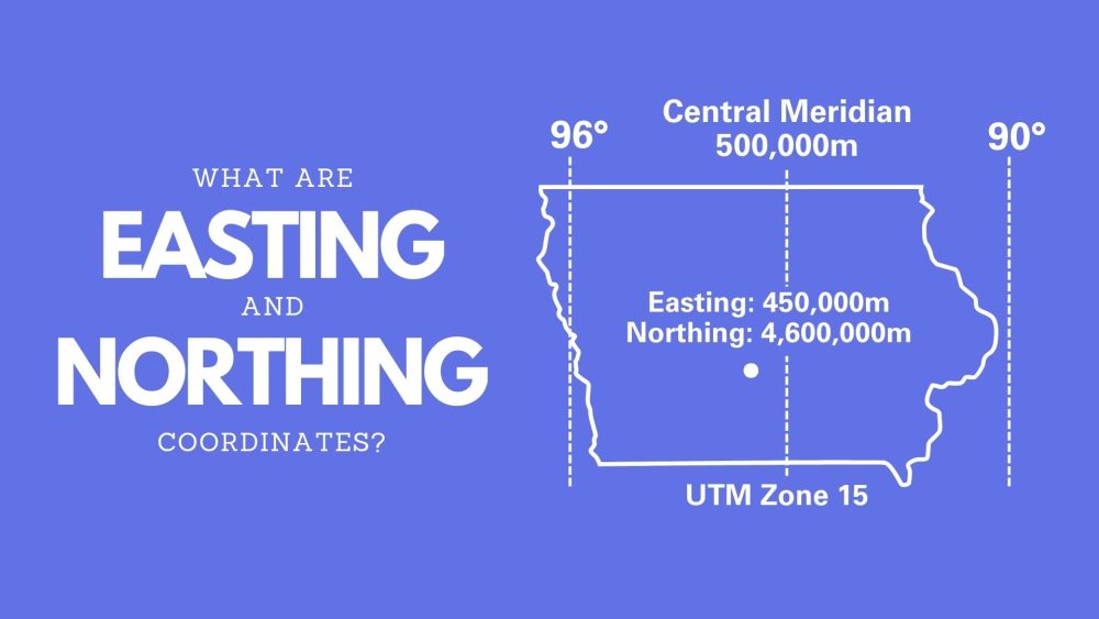
Easting and northing are the x and y coordinates, respectively, in a grid-based system. They are part of a projected coordinate system, which transforms the Earth’s curved surface into a flat, 2D plane.
- Easting measures the distance east of the origin (or central meridian) of the projection.
- Northing measures the distance north of the origin (or equator) of the projection.
2. Understand the Role of Map Projections
Easting and northing coordinates are always tied to a specific map projection. Common projections like Universal Transverse Mercator (UTM) or State Plane Coordinate System (SPCS) are designed to minimize distortion in a particular area.
- UTM divides the Earth into 60 zones, each with its own central meridian. Easting values start at 500,000 meters (to avoid negative numbers) at the central meridian and increase eastward.
- SPCS is tailored for specific U.S. states, providing high accuracy within those regions.
3. Master Units of Measurement
Easting and northing coordinates are typically measured in meters, but this can vary depending on the projection and region. For example:
- UTM uses meters.
- SPCS may use meters or feet, depending on the state.
4. Learn to Read and Interpret Coordinates
Interpreting easting and northing values requires understanding their structure. For instance, in UTM:
- The first number is the easting (east-west position).
- The second number is the northing (north-south position).
5. Use Tools and Software Effectively
Modern GIS software like ESRI ArcGIS, QGIS, or Google Earth Pro simplifies working with easting and northing coordinates. Here’s how to leverage them:
- Input Coordinates: Enter easting and northing values directly into the software to locate points.
- Transform Projections: Convert coordinates between different projections (e.g., UTM to latitude/longitude).
- Validate Data: Use tools to check for errors in coordinate values.
Historical Context: The Evolution of Coordinate Systems
The concept of easting and northing dates back to the 18th century, when cartographers began developing grid-based systems to simplify mapping. The UTM system, introduced in the 1940s, revolutionized global mapping by providing a standardized grid for military and civilian use.
Future Trends: Digital Twins and High-Precision Mapping
As technology advances, easting and northing coordinates are becoming integral to digital twins—virtual replicas of physical environments. High-precision mapping, enabled by GPS and LiDAR, relies on accurate easting and northing data to create detailed 3D models of cities, infrastructure, and natural landscapes.
FAQ Section
What is the difference between easting/northing and latitude/longitude?
+Easting and northing are part of a projected coordinate system (flat grid), while latitude and longitude are part of a geographic coordinate system (curved surface). Projections minimize distortion in specific areas.
Can easting and northing values be negative?
+In most systems (e.g., UTM), easting values start at 500,000 meters to avoid negatives. However, in some local projections, negative values are possible.
How do I convert easting/northing to latitude/longitude?
+Use GIS software or online tools like the Earth Point converter, ensuring you input the correct projection.
Why are easting values offset by 500,000 meters in UTM?
+This offset prevents negative easting values, making calculations and data handling easier.
By mastering easting and northing coordinates, you’ll gain a powerful tool for precise spatial analysis and mapping. Whether you’re planning infrastructure, conducting research, or exploring the world, these coordinates are your gateway to understanding our planet’s geography.


